If you have been to Amsterdam you know how beautiful a city it is. By and large it escaped the same level of war damage compared to other European cities. Most of the 1700 and 1800 buildings have been preserved.
Oddly our neighbourhood is different. While there are pockets of beauty, there are also huge areas of brutalist 1970s buildings which don’t fit in at all.
Why?
As our guide kept saying on the walking tour last Sunday, nothing happens completely randomly. There is a reason why things are the way are.
This map tells the story.
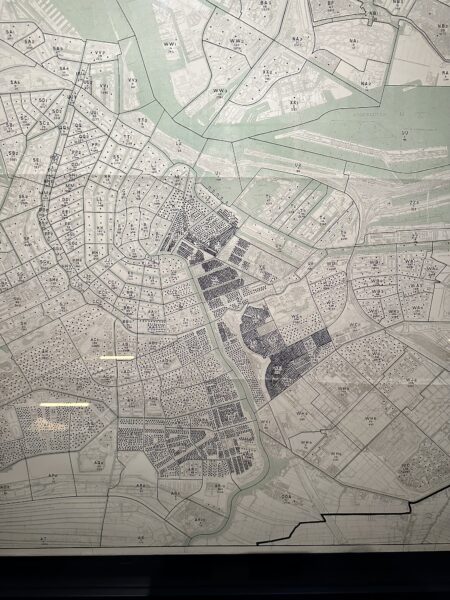
When the nazi army occupied Amsterdam in 1940 one of the first things that they did was require all residents to register with the new government. They used this information to develop maps of the population distribution throughout the city. This map shows the location of the Jewish population. Each tiny dot represents 10 Jews.
The area we are staying in is the area with all of those black dots just SE of the city centre. Most of the Jews died during the holocaust – roughly 80 % of the pre-war population.
After the war their houses and businesses sat empty. No one knew if their owners were still alive or who owned the buildings now. During the counter-culture rebellion of the 1970s people poured into Amsterdam. Many squatted in these empty buildings.
The buildings eventually became terribly unsafe and were gradually torn down by the city. They were replaced with the boxy concrete blocks we see today.
Interestingly, there is a move afoot to tear these buildings down and replace them with more traditional looking buildings.